
Notice to Mariners
Starting approximately 13 August 2021 and continuing until approximately 31 August 2021 the Weeks Marine’s hydraulic dredge C. R. McCaskill and attendant plant will be dredging fill material from a borrow area located just west of Anna María Island between the following approximate positions:
27°32’32.21″N, 82°45’47.02″W
27°32’31.83″N, 82°46’33.12″W
27°31’57.10″N, 82°46’32.74″W
27°31’55.91″N, 82°45’47.65″W

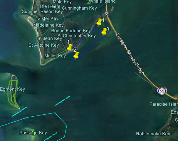
Continuing until approximately 15 September 2021 equipment and dredge pipeline will be anchored in a staging area located just east of Mullet Key, St. Petersburg, FL, bound by the following approximate positions:
27°37’17.85″N, 82°42’44.01″W
27°36’55.02″N, 82°42’21.98″W
27°38’5.61″N, 82°40’49.75″W
27°38’33.55″N, 82°41’12.44″W
All equipment and pipeline will have all required lighting for night operations. The staging area will be used throughout the duration of the project. Fill material will be transported via scows and deposited along the Longboat Key beach fill area using a combination of floating and submerged pipeline. The proposed pipeline (PL) corridors will be bound by following approximate positions:
PL Corridor 1:
27°26’30.87″N, 82°41’24.26″W
27°26’23.46″N, 82°42’47.57″W
27°25’23.05″N, 82°42’45.81″W
27°24’25.97″N, 82°41’50.47″W
27°25’15.18″N, 82°40’21.11″W
27°26’09.18″N, 82°41’21.55″W

The scow(s) route will be bound by the following approximate positions:
27°22’39.54″N, 82°41’49.61″W
27°24’28.78″N, 82°39’24.74″W
27°32’32.21″N, 82°45’47.02″W
27°32’31.83″N, 82°46’33.12″W
27°31’24.45″N, 82°48’13.45″W

Once underway, dredging operations will continue on a twenty-four (24) hours per day, seven days per week basis. The dredge, pipeline and attendant plant will have all required Coast Guard lighting for night operations. The dredge and tugs will monitor marine VHF channels 13 and 16. Mariners are urged to use extreme caution and transit the area at their slowest safe speed to create minimum wake after passing arrangements have been made.