Project History
Port Canaveral’s Inlet Management Plan and Sand Bypassing

Aerial View of Port Canaveral c.1959-60
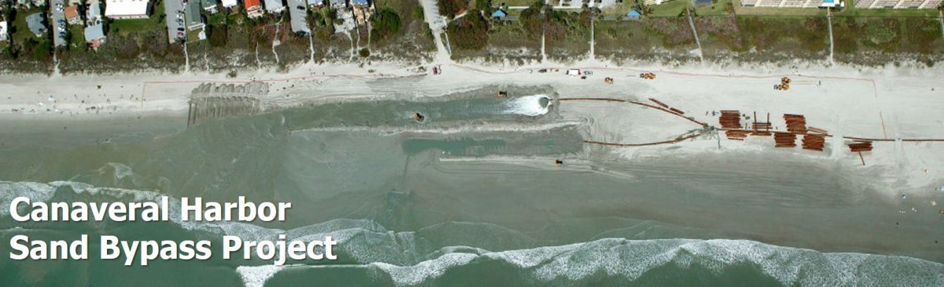
The Canaveral Harbor Federal Sand Bypass project is an integral part of the “Port Canaveral Inlet Management Plan”. The Plan was adopted in the early 1990’s to reduce inlet-adjacent beach erosion and inlet dredging requirements. The sand bypassing project uses a hydraulic dredge and temporary pipeline to periodically transfer sand from the beach north of the inlet to the beaches south of the inlet. This replaces the natural north-to-south drift of sand that is otherwise interrupted by the inlet’s navigation channel and jetties.
Port Canaveral is a man-made inlet and deep-water port constructed by the United States government as a federal navigation project between 1951 and 1954. The entrance channel, protected by duaI rock jetties, is maintained to a depth of 46 feet to accommodate U.S. Navy Trident class submarines.

Port Canaveral c.1990
(Note offset between north and south sides of entrance channel)
The construction of Port Canaveral and the associated jetties interrupted the predominant southerly drift of sand along the Atlantic shoreline. Federal studies as early as 1962 noted that construction of the Port Canaveral jetties and navigation entrance resulted in beach erosion on the south side of the jetties and accretion of sand north of the jetties. By the early 1990’s, the shoreline at the south jetty had receded by over 600 feet while the shoreline at the north jetty had widened by over 900 feet, and at least 7 million cubic yards of beach-quality sand had been dredged from the channel for maintenance and placed in deep water, offshore.

South Jetty Pre-IMP repairs (1994)
Port Canaveral was the first deep water port in the state to formulate an inlet management plan. When the plan was developed in 1992-94, it identified the extent of the navigation project’s impacts upon the adjacent beaches and included a detailed outline of strategies that would restore the natural sand bypassing rate at the inlet, renourish the eroded southern beaches, improve navigation and decrease dredging requirements. Twenty-four separate components made up the plan, approved by the State of Florida in 1996. These components can be grouped into five categories: sand bypassing, nearshore disposal of maintenance-dredged sand, jetty tightening and extension, deposition basins to capture sand before it enters the inlet channel, and beach renourishment to mitigate the inlet’s historical erosion impacts. Within 15 years of its development, all of the plan’s components were implemented or ongoing through cooperative efforts of the U. S. Army Corps of Engineers, Canaveral Port Authority, Brevard County, 45th Space Wing U. S. Air Force, and the Florida Dept. of Environmental Protection, among others.

Elements of 1994 IMP
Implementation of the Port Canaveral Inlet Management Plan has reduced the harbor’s estimated littoral impact of 336,000 cubic yards per year to less than about 20,000 cubic yards per year – a 95% decrease. This has been accomplished through an integrated plan that incorporates modifications in dredging practices, improvements to the inlet jetties, and an innovative sand bypassing program. Every six years (on average), sand bypassing dredges sand from the beach north of the inlet and pumps it through a temporary pipeline to the shoreline within 2.5-miles south of the inlet. Since 1995, four sand bypass project events have transferred about 3.4 million cubic yards of sand from north-to-south across the inlet, equating to an equivalent rate of over 150,000 cubic yards per year. Dredging and transfer of sand accumulation north of the inlet – in addition to a sediment trap on the south side of the inlet – has substantially reduced shoaling of the inlet channel. This has allowed the Corps of Engineers to adopt a 2-year dredging schedule for Canaveral Harbor instead of the annual dredging that was required in the past. Sand-tightened jetties help retain the sand upon the beaches and out of the inlet. Sand that makes its way into the inlet is dredged and loaded separately from non-sandy shoaling, and it is placed in shallow water about six miles south of the inlet. All of these improvements minimize ongoing and future inlet-related beach erosion. Meanwhile, historical erosion that occurred prior to the inlet management plan has been addressed through implementation of the Brevard County Federal Shore Protection Project.
Development and implementation of the Port Canaveral Inlet Management Plan introduced pioneering sand management practices that have nearly eliminated the harbor’s impact to the adjacent shorelines and placed the Canaveral Port Authority among the world’s leaders in successful inlet sand management.
Mitigation of Historical Impacts Brevard County Federal Shore Protection Project
While the sand bypass and other elements of the Port Canaveral Inlet Management Plan minimize current and future inlet impacts to the adjacent shorelines, they could not make up for 40 years of beach erosion. An Independent Coastal Expert study concluded that between 1954 and 1994 — after the inlet’s construction and prior to principal implementation of the Inlet Management Plan — the Canaveral Harbor Federal Navigation Project resulted in 10 million cubic yards of unmitigated beach erosion, extending at least 10 to 15 miles south of the inlet. The Brevard County Federal Shore Protection Project, in part, represents mitigation of the beach erosion that occurred prior to 1994/95.
The North Reach of the project encompasses 9.6 miles of shoreline from Port Canaveral to the northern boundary of Patrick Air Force Base, including Cocoa Beach. It was initially restored with 2.8 million cubic yards of sand nourishment in the winter of 2000/01. It was subsequently renourished with another 750,000 cy of sand in 2005 after severe hurricanes damaged Florida’s beaches in 2004/05, along with about 1,100,000 cy in 2014 and 850,000 cy in 2017/18 to repair damage after Hurricanes Sandy and Matthew/Irma, respectively. The South Reach of the project comprises 4 miles of shoreline between about 22 and 26 miles south of Port Canaveral, including Indialantic/Melbourne Beach. It was initially restored with about 1.6 million cubic yards of sand nourishment in 2002-03; and it was renourished with 580,000 cy in 2004; and about 650,000 cy in each of 2010, 2014, and 2018 to repair hurricane damages. The Mid Reach of the project includes 7.8 miles of shoreline between Patrick AFB and the South Reach, and it features abundant nearshore rock reef that limits sand nourishment along this shoreline. Construction of the Mid Reach project segment was authorized in 2012 and is scheduled to occur in Fall 2019.
 Additionally, Patrick Air Force Base developed and implemented a shore protection project for its 4-mile shoreline, located between 10.6 and 14.6 miles south of Port Canaveral, within the inlet’s influence. The PAFB project adjoins the North Reach (and Mid Reach) project segments. It was initially constructed in 2000/01 with about 560,000 cy of beach nourishment, and it was renourished in 2005 with 320,000 cy of sand. Additionally, in 2011-2018, the Air Force bypassed about 100,000 cy of sand from the beach north of the Port Canaveral inlet, by truck-haul, for placement along the Patrick AFB dunes.
By 2011, the shoreline within 12 miles south of Port Canaveral had been restored to, or

seaward of, the 1950 pre-inlet location. The shoreline within 12 to 15 miles south was within 20 to 60 feet landward of the pre-inlet location. As of 2011, about 70% of the inlet’s total historical impact upon the 10- to 15-mile downdrift shoreline (estimated as 17.2 million cubic yards of sand since 1954, in the absence of corrective measures) had been mitigated.
The Brevard County Federal Shore Protection Project is a 50-year authorized project with the U. S. Army Corps of Engineers. The costs of the South Reach and Mid Reach segments are typically shared by the federal government (about 54%), Brevard County/Space Coast Tourist Development Council (23%) and the State of Florida (23%). Costs of the North Reach segment – and the Patrick AFB project constructed by the U. S. Air Force – are 100% federal. Adoption of 100% federal cost-share for a shore protection project is very unusual. It reflects the findings of the Independent Coastal Expert study on the inlet’s impact upon the adjacent shores, in 2002, for which the Canaveral Port Authority was the local sponsor.